Industries
Audit-ready evidence for carbon projects, from open Sentinel-2
Carbon project developers get evidence a verifier can re-derive: each GammaEarth output comes from a public, citable Sentinel-2 scene, super-resolved from free 10 m input to 1 m across all 10 spectral bands. Baselines reach back to 2018, a fresh scene arrives every five days, and pricing is per km², sized for scattered project parcels.
See the difference
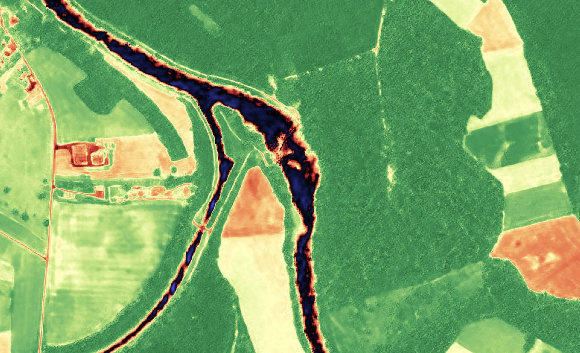
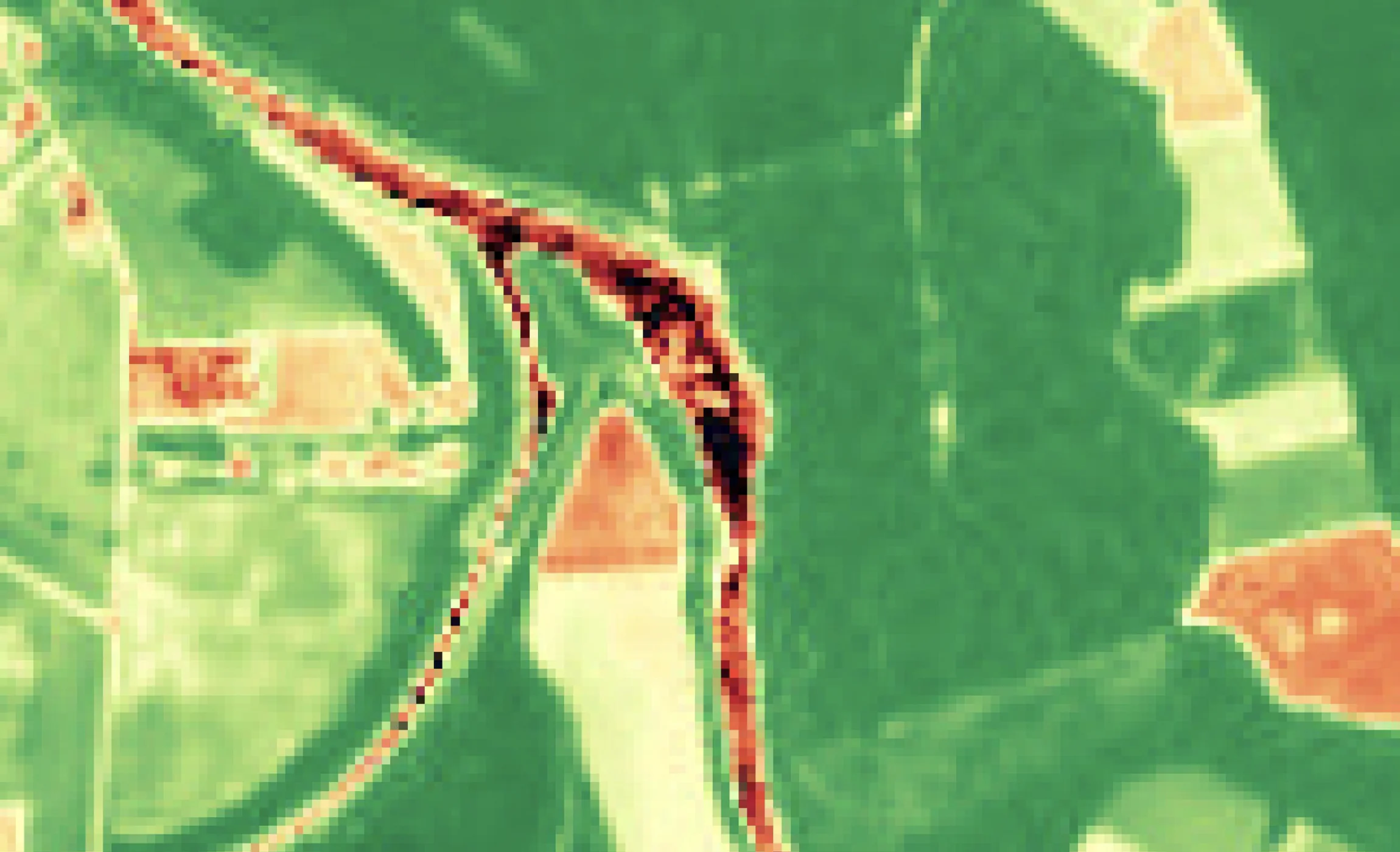
A vegetation index at 10 m, and the same scene at 1 m
Sentinel-2 · 10 m
S2DR3 · 1 m
Sentinel-2 vegetation index over a river floodplain of fields and woodland at 10 m, beside the GammaEarth S2DR3 output at 1 m, where field boundaries and the river channel resolve as distinct edges.
Audit-ready monitoring
The source scene is public, so the result is checkable
Give verifiers a result they can re-derive
Every GammaEarth output is processed from a public Sentinel-2 scene with a known acquisition date — so the input to MRV (measurement, reporting and verification) is free and citable, and a verifier can obtain the same source scene and check the result independently.
Establish the baseline after the fact
Any Sentinel-2A or Sentinel-2B scene from 2018 onwards can be super-resolved to 1 m/px, so a pre-project baseline can be documented retrospectively for any parcel — the before-record exists even where nobody commissioned imagery at the time.
Watch permanence on a five-day cycle
Sentinel-2 images the whole planet every five days, for free, and each new scene can be super-resolved to 1 m on demand. S2DR4 (Sentinel-2 Deep Resolution 4) adds automated cloud, haze and shadow removal, which keeps the monitoring series usable through cloudy seasons.
Feed dMRV pipelines through one API
dMRV (digital measurement, reporting and verification) platforms for nature-based solutions consume dated, analysis-ready rasters. Process the same project AOIs (areas of interest) on a fixed cadence through the API or Python SDK, and each date arrives as 16-bit GeoTIFF (COG ready — cloud-optimised GeoTIFF).
Cost and access
Project evidence does not need a tasked-imagery budget
1 m is sufficient for the project record
Super-resolved Sentinel-2 output at 1 m/px is sufficient for documenting a pre-project baseline, following ARR (afforestation, reforestation and revegetation) growth, catching encroachment while it is small and monitoring permanence — and no tasking queue stands between a project and its evidence: Sentinel-2 has already imaged every parcel, and re-images it every five days, for free.
Priced for parcels, not campaigns
Carbon project areas are rarely one contiguous block. One credit processes one km² of Sentinel-2 imagery in standard regions, at €2.00 per credit from a 100-credit (€200) minimum — a 200 km² project area is 200 credits (€400) per fully processed date, however scattered its parcels. 20 free scenes through Google Colab let you test over project parcels before buying credits.
See pricingA record that can be re-issued for audit
Every output is anchored to a public Sentinel-2 acquisition and its date, and retrieving an already-processed date is free — the same dated record can be pulled again for an audit years into a crediting period. Credits stay valid for 24 months.
Ten bands for vegetation, water and soil
Deliverables are the full 10-band multispectral product at 1 m/px — including the red edge, NIR (near infra-red) and SWIR (short-wave infra-red) bands that respond to canopy and moisture — plus derived RGB, NDVI (normalised difference vegetation index) and IRP (infra-red pseudo-colour) composites.
Use cases
From baseline to crediting period
Pre-project baseline establishment
Super-resolve scenes from before the project began — any Sentinel-2 scene from 2018 onwards — and document the land's prior state at 1 m, parcel by parcel, from the public archive.
ARR growth monitoring
Follow ARR (afforestation, reforestation and revegetation) parcels season by season: canopy establishing and closing at 1 m in NDVI and the infra-red bands, against the pre-planting record.
Avoided-deforestation surveillance
REDD+ (Reducing Emissions from Deforestation and forest Degradation) projects stand on showing the forest still stands. A fresh scene every five days, super-resolved to 1 m, catches encroachment while it is small.
Wetland and mangrove restoration
Track restoration of wetlands, peatlands and mangroves: the SWIR bands respond to surface water and moisture, and at 1 m the restored area's edge is a line rather than a mixed pixel.
Permanence monitoring
A crediting period runs for decades, and the input archive keeps recording regardless. Monitor the standing vegetation that stored carbon depends on, on a five-day cadence, and re-issue any processed date free for audit.
Site-rehabilitation compliance
Document mining and industrial site rehabilitation against permit conditions: dated 1 m imagery of revegetation progress, from the pre-disturbance archive through to closure. Reporting for a corporation rather than running a project?
See Sustainability & ComplianceFAQ
Carbon monitoring questions
What is dMRV and how does satellite imagery support it?
dMRV is digital measurement, reporting and verification — MRV run on instrument data and auditable pipelines rather than periodic field campaigns alone. GammaEarth turns free Sentinel-2 imagery from 10 m to 1 m resolution across all 10 spectral bands and delivers it through an API, so a dMRV pipeline receives dated, analysis-ready 1 m rasters of every project parcel.
Is super-resolved Sentinel-2 imagery good enough for carbon MRV?
Yes. For establishing baselines, tracking ARR (afforestation, reforestation and revegetation) growth and monitoring permanence, 1 m/px output in all 10 spectral bands carries the canopy and moisture signals the work needs — from a public scene a verifier can cite. It also keeps monitoring within a project budget: quarterly processing of a 200 km² project area is 800 credits (€1,600) a year in standard regions.
How do you establish a carbon project baseline retrospectively?
Any Sentinel-2A or Sentinel-2B scene from 2018 onwards can be super-resolved to 1 m/px, so the pre-project state of any parcel can be documented after the fact — a baseline from the public archive, whether or not imagery was commissioned at the time.
Can carbon offset verification use free satellite data?
Yes. The input is the public Sentinel-2 archive — free, citable and re-acquired every five days — and GammaEarth super-resolves it to 1 m on demand. Because the source scene is open, a verifier can obtain the same acquisition and check any result independently, which is what makes the evidence reproducible.
How often can a reforestation project be monitored by satellite?
An ARR (afforestation, reforestation and revegetation) site is re-imaged every five days: Sentinel-2 covers the whole planet on that cycle, for free, and each scene can be super-resolved to 1 m. S2DR4 (Sentinel-2 Deep Resolution 4) handles cloud, haze and shadow removal, so the monitoring series holds through cloudy seasons.
What does satellite monitoring cost for a carbon project?
Per km² and per processed date: one credit is €2.00 and covers one km² in standard regions, with 100 credits (€200) as the minimum purchase — a 200 km² project area comes to 200 credits (€400) per fully processed date. Once a date is processed it can be re-issued at no charge across the crediting period, and unused credits keep for 24 months. Corporate supply-chain reporting is covered separately on the Sustainability & Compliance page.
Setting up MRV for a project portfolio?
Tell us the parcels, the crediting period and the cadence your methodology needs. We respond within one business day.