Industries
Reproducible 1 m imagery, from a source any reviewer can cite
Researchers work from an input any reviewer can obtain: GammaEarth's S2DR3 deep-learning model (Sentinel-2 Deep Resolution 3) super-resolves free, public Sentinel-2 scenes from 10 m to 1 m across all 10 spectral bands, and the method is published with its limits. Academic tiers grant yearly credits at no cost, and standard pricing is per km², sized for a grant budget.
See the difference
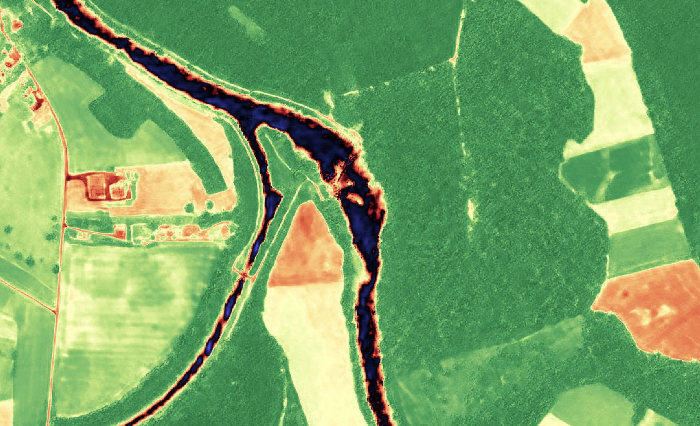
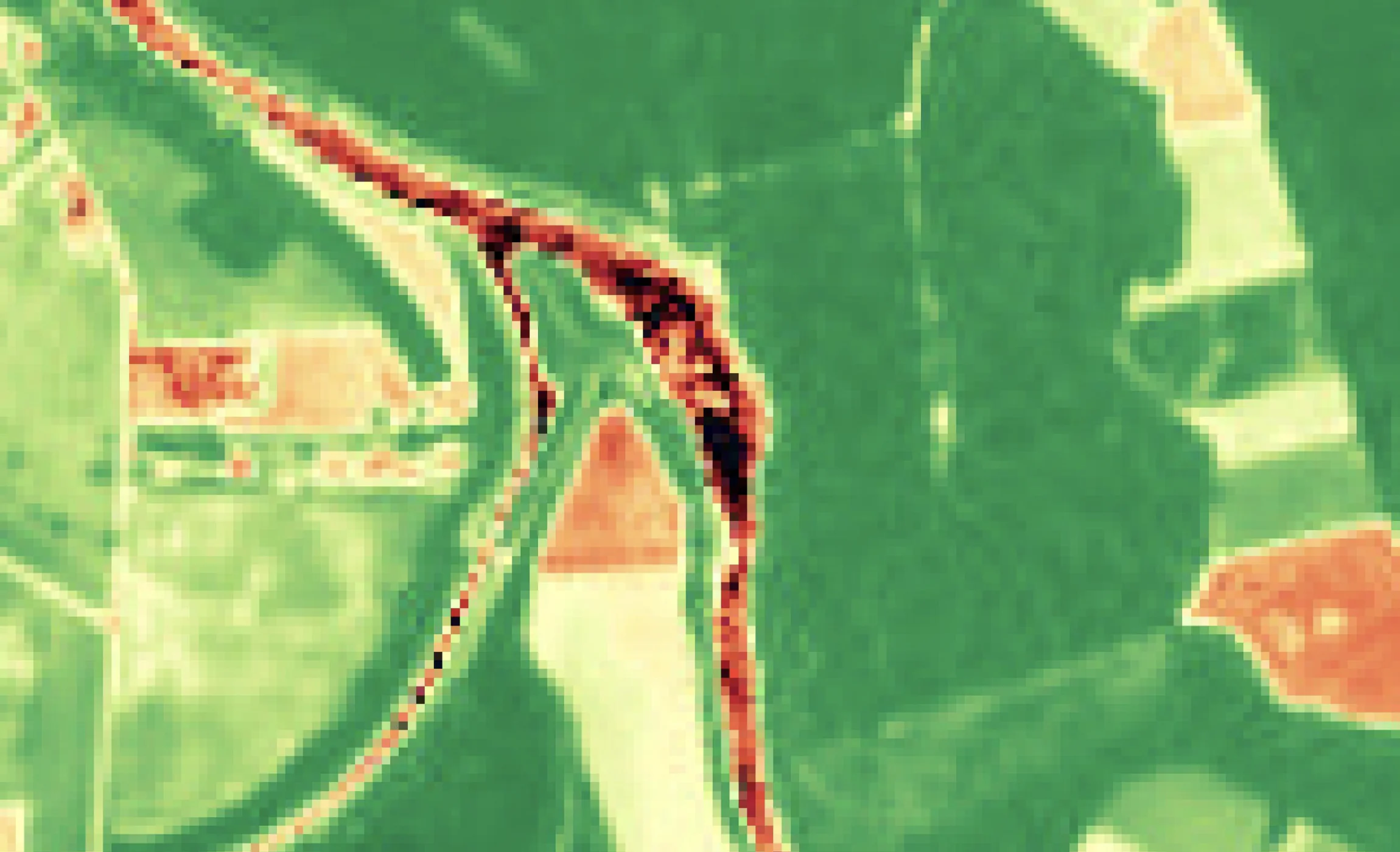
A vegetation index at 10 m, and the same index at 1 m
Sentinel-2 · 10 m
S2DR3 · 1 m
Sentinel-2 vegetation index over a river floodplain of fields and woodland at 10 m, beside the GammaEarth S2DR3 output at 1 m, where field boundaries and the river channel resolve as distinct edges.
Reproducible by design
The input is public, the method is published
Reviewers can obtain the source scene
Every output derives from a public Sentinel-2 L2A (Level-2A surface reflectance) scene with a known acquisition date. The input behind any figure in a paper is free and citable, so a reviewer or a replication study can start from the same data.
All 10 bands survive super-resolution
S2DR3 performs Sentinel-2 super-resolution from 10 m to 1 m across all 10 spectral bands — red edge, NIR (near infra-red) and SWIR (short-wave infra-red) included — so band ratios and indices remain computable at 1 m, not just an RGB rendering.
Longitudinal studies reach back to 2018
Super-resolve any Sentinel-2A or Sentinel-2B scene from 2018 onwards to 1 m/px — a consistent series over any site on Earth, with new global coverage every five days. S2DR4 (Sentinel-2 Deep Resolution 4) adds automated cloud, haze and shadow removal, which keeps a time series usable over persistently cloudy study areas.
Scripted, repeatable retrieval
Orders run through the Python SDK or API and return 16-bit GeoTIFF (COG ready — cloud-optimised GeoTIFF) at 1 m/px GSD (ground sample distance) in UTM projection — a processing step a methods section can state in one sentence, and a pipeline can rerun.
Method transparency
Read the method before you trust the output
S2DR3: the method, documented
Sentinel-2 Deep Resolution 3.0 documents the model's spectral fidelity, the limits of its spatial reconstruction, and the metrics used to evaluate both.
Read the S2DR3 articleS2DR2: the validation argument
The predecessor model's article makes the case for treating Sentinel-2 super-resolution as measurement rather than decoration — what 1 m/px means when the sensor is 10 m/px, and where the model fails. Superseded, and kept as a record of the method.
Read the S2DR2 articleLUCERA: land-use classification research
For land-use research: LUCERA takes CORINE's class definitions into the AlphaEarth embedding space, then densifies and extrapolates them — no spectral signatures, one model for every region.
Read the LUCERA articleEvery model ships with its limits
The publications index collects GammaEarth's research notes on Sentinel-2 super-resolution and land-use classification, each with its evaluation method and the known limits of the model it documents.
Browse all publicationsAcademic Program
2,000 or 6,000 credits a year, at no cost
Associate: 2,000 credits a year
Undergraduate and master's students and PhD candidates enrolled at an accredited institution receive 2,000 credits per year, at no cost, for non-commercial research and teaching.
See eligibility and termsResearcher: 6,000 credits a year
Faculty and teaching staff, postdoctoral researchers and independent researchers with a current institutional affiliation receive 6,000 credits per year, at no cost.
How to applyNon-commercial use, through the Python SDK
The allowance is used through the GammaEarth Python SDK, with an API key issued to your account. It covers academic research and teaching; output may not be resold, sublicensed, or used in commercial work, either as a deliverable or as an input to one.
Every publication carries the S2DR3 reference
Any paper, preprint, poster, thesis, or dataset derived from S2DR3 or S2DR4 output must cite the following reference, exactly as written: Yosef Akhtman, S2DR3: Effective 10-Band 10x Single Image Super-Resolution for Sentinel-2. Gamma Earth, Medium, 2023: https://medium.com/@ya_71389/c71a601a2253
Grant economics
A study budget does not need a tasked-imagery line
1 m is sufficient for measurement, not just illustration
With all 10 spectral bands preserved at 1 m/px, super-resolved Sentinel-2 output is sufficient for long-term land-change series, urban green-space structure, coastal and geomorphological change and monitoring around heritage sites — indices stay computable, and no acquisition budget constrains where the study sites can be.
A study area is priced in km²
Credits cost €2.00 each with a minimum purchase of 100 credits (€200), and one credit processes one km² of Sentinel-2 imagery in standard regions — a 50 km² study area is 50 credits (€100) per processed date.
No tasking, and no re-billing during revisions
Sentinel-2 images the whole planet every five days, for free, and any Sentinel-2A or Sentinel-2B scene from 2018 onwards can be super-resolved to 1 m/px on demand. Charges apply per newly processed date, and retrieving an already-processed date is free — the data behind a questioned figure can be pulled again during review. Credits stay valid for 24 months.
Test everything before spending anything
The free tier processes 20 scenes through Google Colab, in the browser, with nothing to install — enough to run S2DR3 over your own study sites and inspect every band before any credits are bought.
How the trial worksUse cases
From a single site study to a course dataset
Long-term land-change studies
A consistent 1 m series from 2018 onwards over any study site — change analysis on one public sensor family rather than a mosaic of sources.
Super-resolution and downscaling research
Use S2DR3 output as a comparison method, a baseline, or a study object in its own right — the method is published, and the input scenes are open.
Urban green-space and climate studies
Street trees, parks and courtyard vegetation resolve at 1 m in NDVI (normalised difference vegetation index) and the red-edge bands — vegetation structure inside the city fabric, not a district average.
Coastal and geomorphological change
Shorelines, channels and dune edges move at scales a 10 m pixel blurs. At 1 m, with scenes every five days since 2018, that migration becomes measurable.
Archaeology and heritage monitoring
Monitor sites and their surroundings at 1 m — encroachment, ploughing and construction near protected areas — with a dated archive reaching back to 2018 for any site on Earth.
Teaching datasets for courses
The Associate tier grants students 2,000 credits a year at no cost, and the free Colab trial needs no installation — real multispectral data for remote-sensing coursework, at a resolution students can interpret visually.
FAQ
Research access questions
Who qualifies for free academic credits for satellite imagery?
Students and researchers at accredited academic institutions. The Associate tier grants undergraduate and master's students and PhD candidates 2,000 credits per year at no cost; the Researcher tier grants faculty, postdoctoral researchers and independent researchers with a current institutional affiliation 6,000 credits per year. Both cover non-commercial research through the Python SDK — apply from your institutional email address.
Can I run S2DR3 for free?
Yes. The free tier processes 20 scenes through Google Colab, in the browser, with nothing to install — enough to run S2DR3 over your own study sites before deciding anything. Students and researchers at accredited institutions can go further: the Academic Program grants 2,000 credits a year to students and PhD candidates and 6,000 a year to affiliated researchers, at no cost, for non-commercial research.
How do I cite S2DR3 in a paper?
Any paper, preprint, poster, thesis, or dataset derived from S2DR3 or S2DR4 output must cite the following reference, exactly as written: Yosef Akhtman, S2DR3: Effective 10-Band 10x Single Image Super-Resolution for Sentinel-2. Gamma Earth, Medium, 2023: https://medium.com/@ya_71389/c71a601a2253
Is super-resolved satellite imagery reproducible for peer review?
Yes. Every GammaEarth output derives from a public Sentinel-2 L2A (Level-2A surface reflectance) scene with a known acquisition date, so a reviewer can obtain the identical source data. The S2DR3 method is published with its evaluation metrics and known limits, and retrieving an already-processed date is free — the same product can be pulled again during a revision cycle.
Is super-resolved Sentinel-2 imagery good enough for research use?
Yes, for study designs that need structure finer than the sensor's 10 m grid without losing spectral integrity: all 10 bands survive super-resolution to 1 m/px, so indices and band ratios stay computable, and the S2DR3 method is published with its known limits. Access matches a research budget: 20 free scenes run through Google Colab with nothing to install, academic tiers grant 2,000 or 6,000 credits a year at no cost, and outside the programme a 30 km² study site is 30 credits (€60) per processed date in standard regions.
What format does the data come in for analysis?
Analysis-ready rasters: 16-bit GeoTIFF (COG ready — cloud-optimised GeoTIFF) at 1 m/px GSD (ground sample distance) in UTM projection, carrying all 10 multispectral bands together with derived 3-band RGB, NDVI (normalised difference vegetation index) and IRP (infra-red pseudo-colour) composites, retrieved through the Python SDK or API.
What does a small study area cost outside the academic programme?
A study area is priced in km²: one credit per km² in standard regions, at €2.00 per credit, bought from a 100-credit (€200) minimum — so a 50 km² study area is 50 credits (€100) per processed date. Re-retrieving a processed date during revisions is free, a credit balance carries for 24 months, and the 20-scene Google Colab trial costs nothing at all.
Planning a study on super-resolved Sentinel-2?
Tell us the sites, the period and the bands your method needs — or apply for the Academic Program from your institutional address. We respond within one business day.