LUCERA: Land-Use Classification with Embeddings and Regional Annotations
A framework for high-resolution land-use and land-cover classification using AlphaEarth embeddings
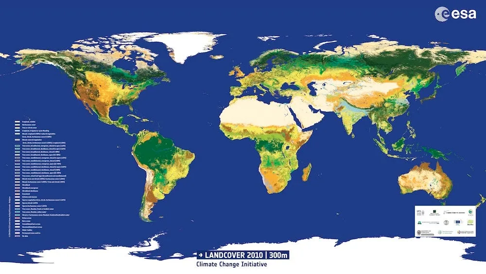
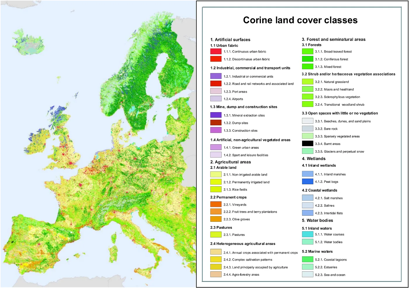
Land-use and land-cover layers sit at the heart of environmental science, agricultural policy, climate modelling, and spatial planning. Yet almost all existing LULC products share a set of structural limitations: they are updated infrequently, their resolution is coarse relative to the scale at which land-use change actually occurs, and their class definitions vary across regions. These issues are exemplified by the CORINE Land Cover illustrated in Figure 1 that provides a harmonised, widely trusted reference in Europe. CORINE remains indispensable, yet its six-year update cycle (most recent update was released in 2018), large minimum mapping unit, and reliance on manual photo-interpretation limit its ability to capture the pace and granularity of modern land-use transformation. Similar constraints apply to global products such as ESA WorldCover (2020 and 2021 only) or GlobeLand30 (2000–2010). Thus far, LULC maps have been produced at a spatial and temporal resolution that are largely insufficient to meet the pressing challenges of our rapidly evolving environment.
LUCERA is designed as a response to this gap. It is a methodology for taking an existing, coarse, slowly updated LULC dataset and transforming it into a spatially dense, regionally extendable, internally consistent land-use map. The current initial implementation of the proposed framework relies on two pillars: the CORINE dataset, which provides a high-quality initialisation of land-use classes in Europe, and the Google AlphaEarth embedding space, which provides a rich, high-resolution, semantically structured representation of the Earth's surface derived directly from high-resolution optical imagery and climate data. The key innovation is that densification and extrapolation do not depend on spectral features or temporal composites but on the geometric and semantic properties encoded within the AlphaEarth embedding space itself.
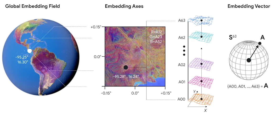
AlphaEarth embeddings represent each small image patch of the planet as a point in a high-dimensional latent space. Patches that are visually and structurally similar lie near one another, no matter where in the world they originate. This latent geometry makes it possible to propagate land-use knowledge from one region to another simply by operating within the embedding space. The idea is straightforward: take CORINE-labelled patches in Europe, embed them via AlphaEarth, and then learn the structure of each land-use class in the latent manifold. Once each class forms a statistically coherent region in the embedding space, it becomes possible to classify any new patch anywhere in the world by identifying which CORINE-derived region of the manifold it falls into. The method does not require spectral signatures, time series, or cloud-free mosaics. It uses only the semantic geometry learned by the AlphaEarth foundation model.
This approach offers several advantages. CORINE provides clean, interpretable, policy-relevant land-use classes that are already aligned with European regulatory practice. AlphaEarth provides dense, globally consistent embeddings produced at high spatial resolution. When combined, the two layers yield a classification pipeline that inherits CORINE's semantic richness but is freed from its spatial constraints. Instead of being tied to a twenty-five-hectare minimum mapping unit, land-use categories become as fine-grained as the embedding patches themselves. Instead of being updated every six years, the output can refresh as often as new imagery is available in AlphaEarth. And instead of being limited to Europe, the model can generalise to any location represented in the embedding space.
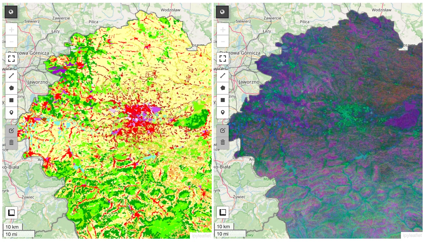
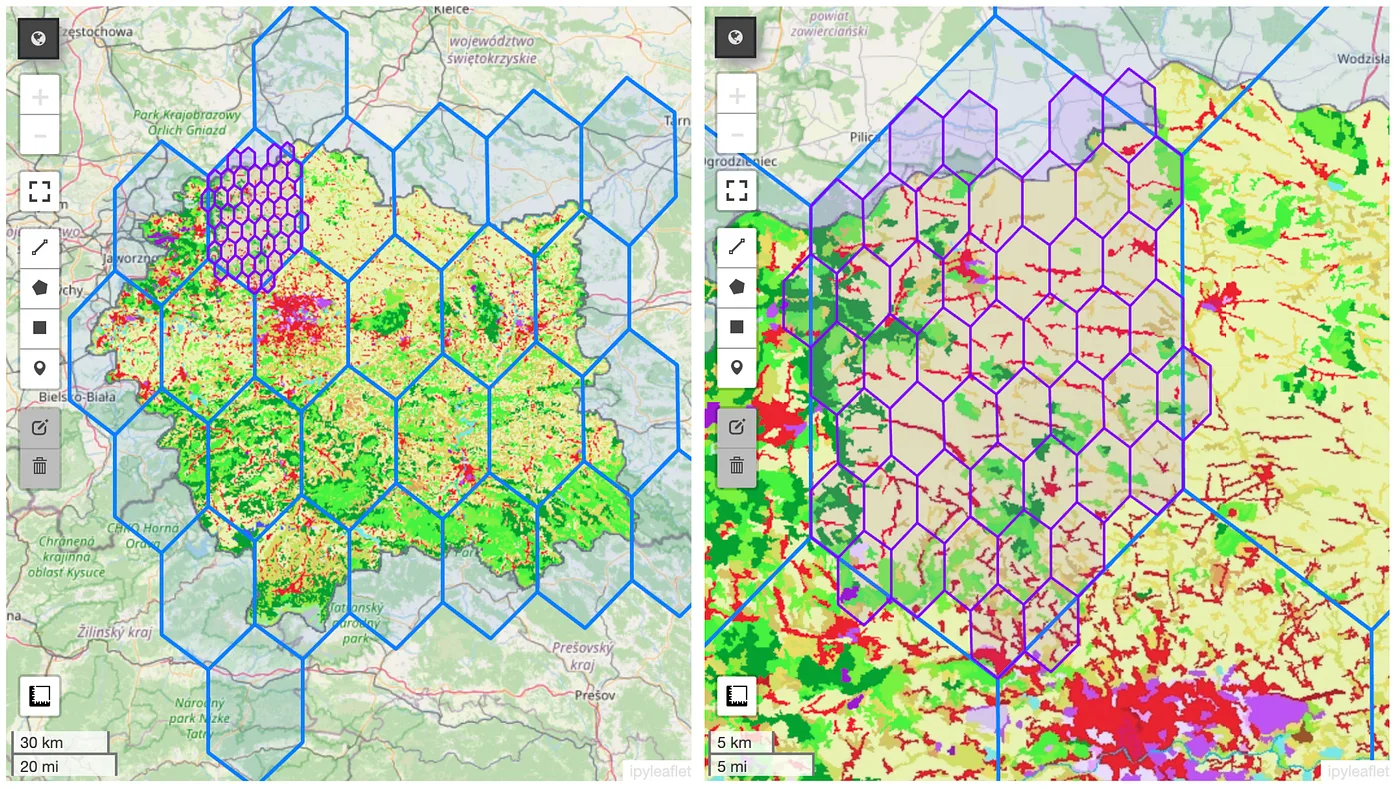
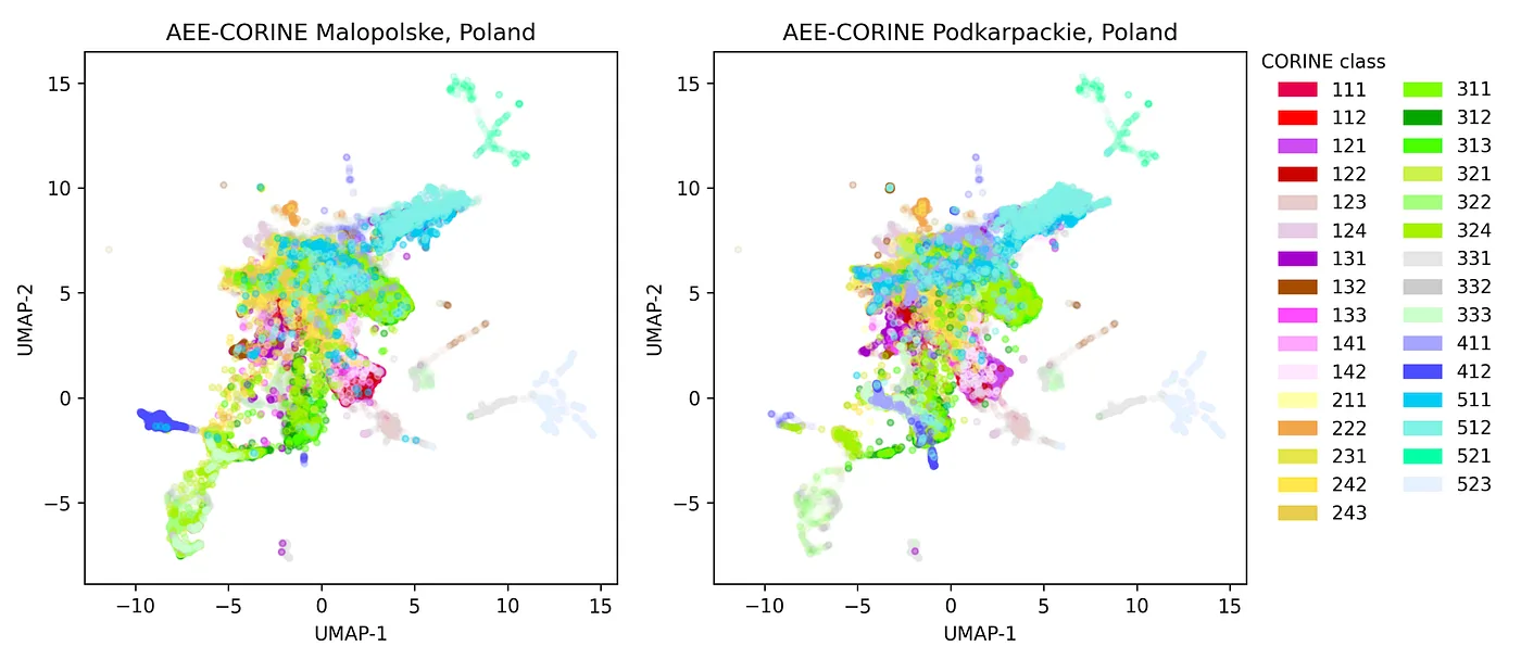
The densification process begins by mapping CORINE labels to their corresponding AlphaEarth embeddings. Each CORINE polygon is broken into small patches, embedded, and used to characterise the statistical structure of each class in latent space. Classes that are visually or structurally heterogeneous — mixed agricultural mosaics, transitional areas, peri-urban zones — naturally form stratified or multi-clustered patterns within the manifold, and the method preserves this complexity rather than forcing an artificial simplification. Once this structure is identified, the model learns to assign class membership to any new embedding by analysing its proximity, neighbourhood structure, and decision boundaries within latent space.
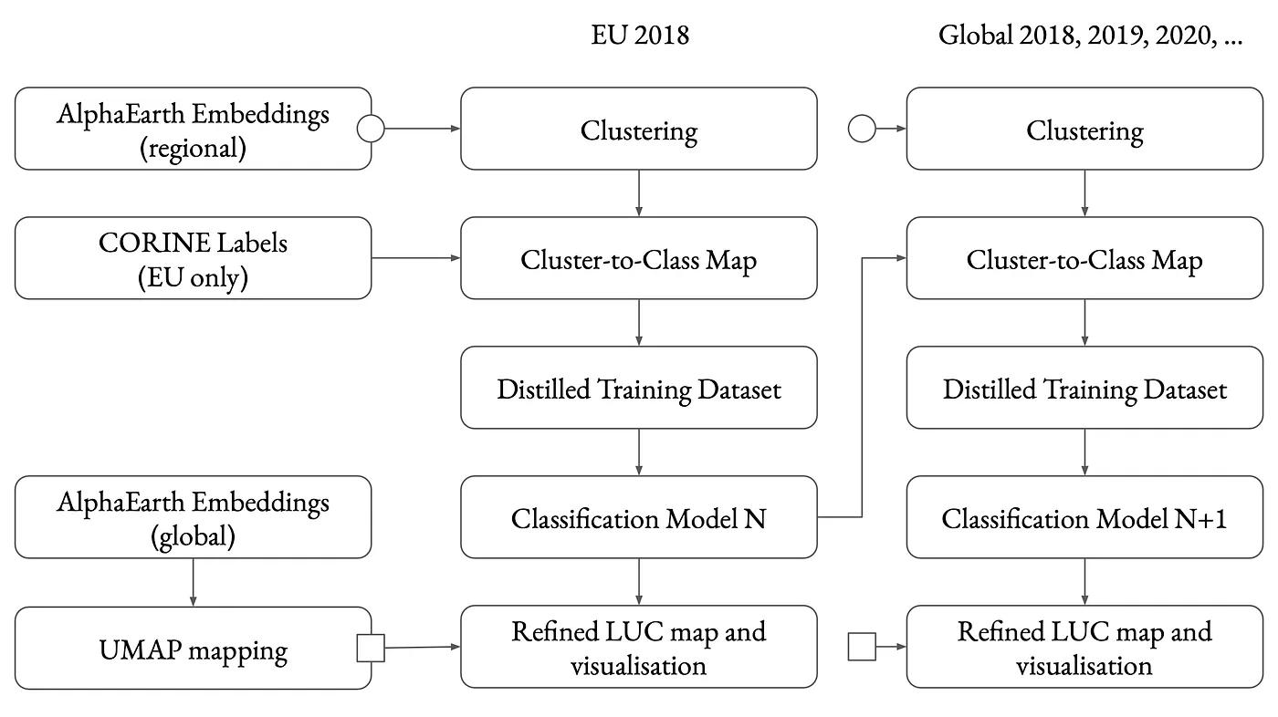
Extrapolation follows the same principle, but with a different purpose. Instead of refining CORINE within Europe, the goal is to apply the CORINE-derived latent structure to new regions where no equivalent ground-truth exists. Because AlphaEarth embeddings are globally coherent, the representation for a patch of land in North Africa, South America, or Central Asia lives in the same semantic space as its European counterparts. This allows CORINE's well-defined class boundaries to extend naturally into new territories. Of course, not all classes generalise equally; agricultural subclasses or region-specific categories may require adaptation. But the latent manifold contains enough visual and structural information to make the extrapolation meaningful and surprisingly reliable, especially for globally recognisable classes such as forest types, open fields, shrublands, bare soil, water, and various artificial surfaces.
One of the strengths of LUCERA is that it creates a land-use system that is both high-resolution and internally stable. Because the classification operates in latent space rather than raw imagery, it becomes robust to differences in illumination, seasonality, sensor metadata, and radiometric idiosyncrasies. AlphaEarth embeddings provide a strongly normalised representation, which makes statistical decision boundaries transferable across continents. As a result, the classification becomes more consistent than what could be achieved through conventional per-pixel spectral modelling, especially in regions with variable atmospheric conditions or sparse historical ground truth.
This method turns the traditional workflow inside out. Instead of building a new supervised model per region, LUCERA trains only once, using European CORINE as the semantic anchor. The learned class geometry in latent space is then applied everywhere. The production of high-resolution LULC maps becomes a problem of embedding computation, density estimation, and manifold classification rather than multispectral analysis. The result is a land-use layer that can be generated with exceptional spatial detail and refreshed frequently, provided that the upstream AlphaEarth embedding pipeline remains active.
The practical applications are wide-ranging. Agriculture benefits from parcel-scale mapping of fields, orchards, terraces, and smallholder structures that lie far below CORINE's spatial threshold. Urban analysis becomes more precise, capturing peri-urban expansion, small construction sites, informal development, and the fine structure of built environments. Ecologists gain access to dense representations of habitat mosaics, vegetation transitions, and small-scale features that are typically invisible in coarse-resolution datasets. Climate and carbon-monitoring initiatives benefit from more accurate delineation of forest boundaries, shrub-to-forest transitions, and non-forested vegetation dynamics. Water-management authorities can track small ponds, drainage structures, and retention features which do not appear in any conventional continental product.
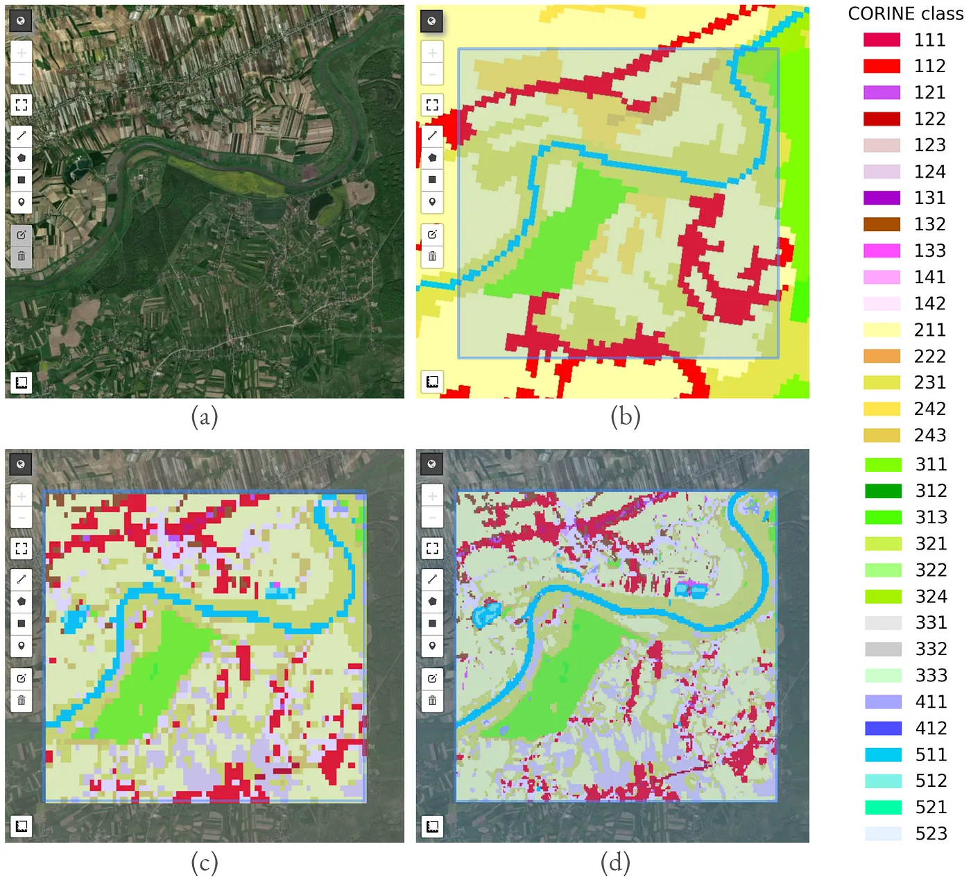
LUCERA's contribution is methodological rather than instrumental. It provides a reproducible path for transforming a coarse but semantically rich dataset into a dense, globally extendable land-use layer without relying on multispectral modelling or temporal composites. The key enabler is the embedding geometry learned by a large-scale foundation model. Once land-use classes are defined within this geometry, the classification problem becomes one of spatial statistics in the latent manifold. This shift makes the method inherently scalable: the same model can densify Europe and extrapolate globally without retraining, and updates become as frequent as the availability of embedding computation.
In a world facing rapid environmental change, fine-scale, frequently refreshed LULC intelligence is no longer optional. It is a prerequisite for effective policy, sustainable agriculture, biodiversity conservation, and climate-risk mitigation. LUCERA offers a way to produce such intelligence using only two elements: a stable, interpretable land-use taxonomy from CORINE, and a high-capacity embedding model that captures the structural organisation of the planet's surface. Together, they create a land-use modelling paradigm that is both high-resolution and globally coherent.
References
- European Environment Agency. CORINE Land Cover 2018. land.copernicus.eu/pan-european/corine-land-cover. Published 2019. Accessed 2025-01-15.
- European Environment Agency. Biogeographical Regions in Europe. eea.europa.eu/data-and-maps. Published 2017. Accessed 2025-01-20.
- Research, G. AlphaEarth Foundations Embedding Model for Remote Sensing. github.com/google/earth-engine-alphaearth. Published 2024. Accessed 2025-02-05.
- Bossard, M.; Feranec, J.; Otahel, J. CORINE Land Cover Technical Guide — Addendum 2000. European Environment Agency, Copenhagen, 2000.
- Buettner, G. CORINE Land Cover and Land Cover Change Products. In: Land Use and Land Cover Mapping in Europe, 2017, pp. 55–74. DOI: 10.1007/978-94-007-7969-3_5.
- European Space Agency. Sentinel-2 Level-2A Imagery. sentinel.esa.int/web/sentinel/missions/sentinel-2. Published 2021. Accessed 2025-01-15.
- Copernicus Land Monitoring Service. EU Digital Elevation Model (EU-DEM) v1.1. land.copernicus.eu/imagery-in-situ/eu-dem/eu-dem-v1.1. Published 2016. Accessed 2025-01-16.